President (To Win Colorado) See Full Big Line

(D) Kamala Harris

(R) Donald Trump

80%

20%

CO-01 (Denver) See Full Big Line

(D) Diana DeGette*

(R) V. Archuleta

98%

2%

CO-02 (Boulder-ish) See Full Big Line

(D) Joe Neguse*

(R) Marshall Dawson

95%

5%

CO-03 (West & Southern CO) See Full Big Line

(D) Adam Frisch

(R) Jeff Hurd

50%

50%

CO-04 (Northeast-ish Colorado) See Full Big Line

(R) Lauren Boebert

(D) Trisha Calvarese

90%

10%

CO-05 (Colorado Springs) See Full Big Line

(R) Jeff Crank

(D) River Gassen

80%

20%

CO-06 (Aurora) See Full Big Line

(D) Jason Crow*

(R) John Fabbricatore

90%

10%

CO-07 (Jefferson County) See Full Big Line

(D) B. Pettersen

(R) Sergei Matveyuk

90%

10%

CO-08 (Northern Colo.) See Full Big Line

(D) Yadira Caraveo

(R) Gabe Evans

70%↑

30%

State Senate Majority See Full Big Line

DEMOCRATS

REPUBLICANS

80%

20%

State House Majority See Full Big Line

DEMOCRATS

REPUBLICANS

95%

5%

Generic selectors
Exact matches only
Search in title
Search in content
Post Type Selectors
April 29, 2011 02:08 AM UTC

Heath Introduces "City Integrity" Map

  • 39 Comments
  • by: Colorado Pols

FOX 31’s Eli Stokols reports, as originally announced by Sen. Rollie Heath last week:

Senate Democrats Thursday afternoon introduced a proposal to re-draw Colorado’s seven congressional districts in a way that makes them more competitive.

This comes after the 10-member bipartisan Joint Select Committee on Redistricting broke down last week, after Democrats and Republicans couldn’t negotiate a compromise between their very different proposed maps…

“Today we introduced a map that honors our charge to create districts that give Coloradans the best congressional representation possible,” said Sen. Rollie Heath, D-Boulder, who co-chaired the committee and is the sponsor of S.B. 268.

“That committee traveled the state listening to folks who said they want fair and competitive districts–districts that don’t create congressmen or congresswomen for life. The map introduced today creates fair, competitive districts that will allow voters to hold their representatives accountable.”

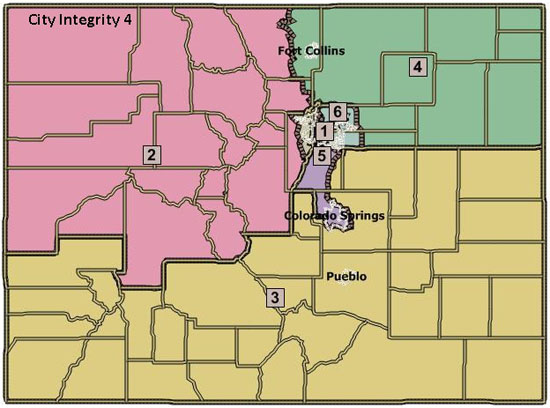
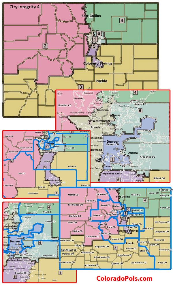
Statement from the Senate Majority Press Office after the jump: it’s our understanding that the map as introduced in bill form is equivalent to the City Integrity 4 map released by Democrats on the Joint Select Committee two weeks ago. (metro area detail–large)

Conveniently, that’s the map we made our splash graphic for our original maps post with (after the jump). We want to assure Sen. Greg Brophy that this is just a coincidence, and ask him to please not go all tinfoil hat on us again. Also, we know that many of you have had the time already to form, you know, robust opinions about the Democratic map proposals. Perhaps a good idea would be to think of some improvements to this map, since that’s what the General Assembly, starting with the Senate State Affairs Committee, will get to do very soon.

We’re watching for developments from the GOP, who has also promised a map(s).

Democrats introduce map to create fair and competitive Colorado congressional districts

“Competitive districts will prevent ‘Congressmen for life’ in Colorado”

DENVER- Today, Senator Rollie Heath (D-Boulder) introduced the first official redistricting map to create fair, competitive congressional districts and protect communities of interest in Colorado. The map was introduced as legislators take on the constitutionally mandated task of redrawing Colorado’s congressional lines every 10 years following the decennial census.

Senator Heath offered the following comment on the map introduced today:

“Today we introduced a map that honors our charge to create districts that give Coloradans the best congressional representation possible. I co-chaired the historic joint select redistricting committee. That committee traveled the state listening to folks who said they want fair and competitive districts–districts that don’t create congressmen or congresswomen for life. The map introduced today creates fair, competitive districts that will allow voters to hold their representatives accountable.”

Competitive districts are good public policy. A district is competitive when there are a balanced number of Republicans, Independents and Democrats. In a balanced district, a candidate from either party can be elected. Competitive districts allow voters to better hold elected officials accountable. Voter registration in the state shows that Colorado’s electorate does not overwhelmingly favor one party over the other, and nearly one-third of the population isn’t registered with either party at all. That is the reason competitive districts make sense for Colorado.

The map introduced by Democrats today demonstrates their commitment to drawing competitive districts. This commitment comes from the work of the historic redistricting committee that was formed to guide the redistricting process. Coloradans told legislators that they want competitive congressional districts so they can hold their representatives accountable and prevent the creation of congressmen for life.

The map proposed by Democrats today reflects the following principles:

1. Provides for equal populations among districts

2. Follows the federal and state law

3. Maintains communities of interest

4. Preserves political subdivisions

5. Assures Competitiveness

Comments

39 thoughts on “Heath Introduces “City Integrity” Map

  1. I know I ought to be more concerned with the whole big picture thing but seeing Littleton in D1 after all my years here, especially the ones with Tancredo and Coffman, just feels so good. Better enjoy the glow now. Probably won’t last.  

    1. You mean I’ve been thrown into the same district as — deep breath — Littleton? Please, don’t take my chastity, too.

      P.S. Welcome to the land of real “community interest” identity confusion.

    1. “Community interest” speaking, that is. Except in its perenniel opposition to the Eastern Slope (Read: Denver [or Boulder]).

      The only thing better (geopoliticopsychologically [Ok, there’s no such word, and it doesn’t have a fucking thing to do with congressional redistricting but a hell of a lot to do with better governance for Colorado on the national scene.] speaking) would be the break-up of CD1. We (here and in the various parts of the Western Slope) really need to start thrashing out our national stance, by way of our Congressional representation. State geography or population density alone can’t be the overriding concerns. That Continental Divide isn’t what it used to be; nor are Colfax or Broadway.

      Ain’t gonna happen though this go-’round. Western Slope will still be a geographical dinosaur district, as will Denver.  

  2. Is that on district only include places where water flows West. Because the direction that water flows trumps all other considerations.

    Why?

    Because some living in the West Slope said so.

    Look people, times change. Demographics change. And while water matters there, and throughout the state, it does not trump everything else.

      1. what would the map look like if insteadf of “city integrity” we had drainage basin integrity?

        Or extraction integrity?

        Or military faccilities integrity?

        1. 100 years ago there would have been a strong argument for districts following rail lines, because that is what tied communities together. And that is how farmers and ranchers shipped their goods out.

          But it would be ludicrous to use that guideline today.

      2. When the Treaty was being negotiated, we (USA) were supposed to get the Colorado river basin – all the way to the Gulf.  It made a lot of sense.   Of course we were supposed to get the Baja too.

      3. Interesting idea, but so much water is shipped east of the divide anymore that it’s unclear how you would draw the map. Water from as far east as the Roaring Fork waters Denver bluegrass. So any map that unites exporters of water with consumers of water would span the continental divide.

        So what arrangement of district would work best for west slope water interests? Is it better to divide congressional districts at the continental divide – and pit wealthy urban districts against rural districts? Would a Front Range greenie actually help the west slope more than a oily GJ Republican? My impression is that the latter will sell you guys down the river (so to speak) in a heartbeat. Meanwhile, most of the arguments against diverting more water hinge on environmental grounds.

    1. West Slopers just have this thang. I’m one (willingly estranged), and I know. You’ve seen the T-shirts that say “It’s a black thang“? There should be one, “It’s a Western Slope thang.” You have to be an insider or married to one to get the real significance.

      David, I’d say the thang is, “Boulder” is just a defensive dog whistle. Like “Front Range”. Or “Metropolitan Denver”, as in “bordering on”. We have to understand: Mesa County, especially, has had a very painful recent history of boom/bust and bust/bust. It’s almost been Cinderella at the ball many times (uranium, shale oil), or it’s been ignored (glitzy Telluride/Aspen gentrification). Mesa County needs Western Slope Unity more than any eventual Western Slope district needs Mesa County.

      That said, if water is the overriding interest, the question arises: Why the preference for buddying the Colorado drainage with the Rio Grande drainage and the Arkansas drainage over the Platte Drainage? Is it just a Western Slope thang?

  3. Boulder and GJ have “common interest”?  Five military bases in Colorado Springs and Highlands Ranch?

    The housing proximity to Denver for our Congressmen/woman is another slap in the face.

    District court.

  4. It ignores nearly every request made by the people who testified in all of those public hearings held across the state:

    Larimer is split.

    Broomfield is separated from Boulder.

    Jeffco remans split up

    DougCo is split into 3 CDs

    El Paso is split into 2 CDs

    ArapCo is split into 3 CDs

    The traditional Western Slope is split

    Ditto for the Eastern Plains.

    Greenwood Village in CD1.

    The only requests they honored was keeping Longmont separate from Boulder and separating Chaffe County from El Paso, although I doubt they thought they would be lumped with Boulder in teh process.

    1. Dan – it looks like you only went to one of the ten meetings held around the State.  If you want to complain about the testimony, I humbly suggest you go to the Redistricting website and listen to the 40 hours that the Joint Select Committee heard.

      http://www.colorado.gov/cs/Sat

      If you listen to all of the testimony, you hear quite a few competing interests.  The only thing that is consistent, is a desire for more competitive districts.

        1. So the Dems’ maps are the only maps that don’t split cities and split no rural counties.

          Repub. maps split rural counties and a whole bunch of cities.

          Both maps split the west slope and both maps split the eastern plains.

          On balance, the Dems’ maps do better.  

          1. Dan Willis’ maps achieve what everyone says they want to achieve, and do so without tying every district to a population center in the northern Front Range. What’s wrong with that?

    2. I know a number of Estes Park residents who are very happy with the proposed Larimer split, and it makes sense from a community of interest standpoint.

      Broomfield doesn’t have much in common with Boulder in my experience; why they want to be lumped in with it I don’t know.

      The JeffCo split is at least more logical than the current split; putting the mountain sections in CD2 places them with similar interests along the Front Range foothills.

      It’s not like this is the only proposed map to split Douglas and Arapahoe – Yours do, too, in fact, and so do the Republicans’.

      El Paso split I won’t try to justify other than to say that the map design requires it.

      The traditional Western Slope has only been so since the 1980’s.  Same with the Eastern Plains.  We have in fact had a map not entirely unlike this one in the past.

      I’m not saying that these aren’t laudable goals, nor discounting the opinions of those who attended the hearings to express themselves.  But neither would I consider them the only valid concerns of people within the various regions, or that those concerns were the only valid concerns allowed in drawing the maps.

    1. Unless Sen. Heath has some secret weapon in the House, introducing this bill is just politics.

      Whether you like the map or not, the political reality appears to be that this thing ain’t going to the governor’s desk or even to the floor of the House.  Is there really something to be gained from the political grandstanding on this?  It seems a bit esoteric for that kind of ploy.

  5. I think it’s a lot more far to throw northern Aurora into D-1 than Littleton.

    I’m happy that I’d live in a moderate republican district now.

    CD-2 amd 3 are really wak though. GJ to Boulder? And the an entire southern district from mountains to plains Utah to Kansas?

    This isn’t the worst map…but it doesn’t excite me overall

Leave a Comment

Recent Comments


Posts about

Donald Trump
SEE MORE

Posts about

Rep. Lauren Boebert
SEE MORE

Posts about

Rep. Yadira Caraveo
SEE MORE

Posts about

Colorado House
SEE MORE

Posts about

Colorado Senate
SEE MORE

109 readers online now

Newsletter

Subscribe to our monthly newsletter to stay in the loop with regular updates!