CO-04 (Special Election) See Full Big Line

(R) Greg Lopez

(R) Trisha Calvarese

90%

10%

President (To Win Colorado) See Full Big Line

(D) Joe Biden*

(R) Donald Trump

80%

20%↓

CO-01 (Denver) See Full Big Line

(D) Diana DeGette*

90%

CO-02 (Boulder-ish) See Full Big Line

(D) Joe Neguse*

90%

CO-03 (West & Southern CO) See Full Big Line

(D) Adam Frisch

(R) Jeff Hurd

(R) Ron Hanks

40%

30%

20%

CO-04 (Northeast-ish Colorado) See Full Big Line

(R) Lauren Boebert

(R) Deborah Flora

(R) J. Sonnenberg

30%↑

15%↑

10%↓

CO-05 (Colorado Springs) See Full Big Line

(R) Dave Williams

(R) Jeff Crank

50%↓

50%↑

CO-06 (Aurora) See Full Big Line

(D) Jason Crow*

90%

CO-07 (Jefferson County) See Full Big Line

(D) Brittany Pettersen

85%↑


CO-08 (Northern Colo.) See Full Big Line

(D) Yadira Caraveo

(R) Gabe Evans

(R) Janak Joshi

60%↑

35%↓

30%↑

State Senate Majority See Full Big Line

DEMOCRATS

REPUBLICANS

80%

20%

State House Majority See Full Big Line

DEMOCRATS

REPUBLICANS

95%

5%

Generic selectors
Exact matches only
Search in title
Search in content
Post Type Selectors
June 29, 2021 11:15 AM UTC

First Look at Legislative Redistricting Maps

  • 9 Comments
  • by: Colorado Pols

UPDATE: As Justin Wingerter reports for The Denver Post, don’t get too attached to these maps. We mentioned earlier that the key word here was PRELIMINARY, and a staffer makes that point in The Post:

“These will never be approved by anyone,” Jessika Shipley, the legislative redistricting commission’s staff director, told commissioners. “They are merely a baseline starting point for conversations across the state.”

Along those lines, someone might need to pour a bucket of cold water on over-excited Republicans:

“These maps are the Colorado political equivalent of a Category 5 hurricane or an earthquake — 10.0 on the Richter scale,” said Alan Philp, a Republican consultant who lobbies the redistricting commission.

A HUGE EARTHQUAKE…that “will never be approved by anyone.”

—–

The nonpartisan staff of the Colorado Independent Redistricting Commissions today released its first effort at proposed new maps for State House and State Senate districts in 2022.

CLICK HERE to view the State House district map.

CLICK HERE to view the State Senate district map.

You can see a zoomed-in version of the State Senate map below, but you really need to click on the links above to get a better look. As we noted last week when the first Congressional redistricting map was released, THESE ARE PRELIMINARY MAPS ONLY.
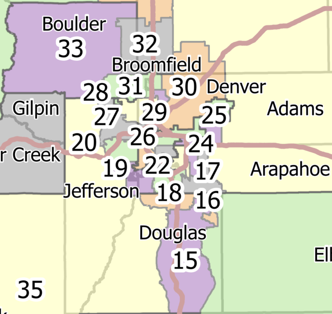
Metro-area look at State Senate redistricting proposal.

Comments

9 thoughts on “First Look at Legislative Redistricting Maps

  1. Wow! Just looking at Denver, it is a radical change from the current map, especially on House side. It looks like Denver looses another Rep. (We lost one in 2001 also)

    On the Senate map, they divide my neighborhood, but yet have another county included with us, yuck!

    I've been out of statewide politics long enough that's I'll only comment on Denver, where I live.

  2. Ugh.  Gilpin goes in with Grand and Clear Creek for the House.  That sucks.  Grand should be in a western profile.  Gilpin and Grand have little in common except the Divide.

  3. The more I look at the HD map, the more I don't like what is happening to Denver.  I wasn't going to get involved with the legislative redistricting, and only focus on congressional, but I do feel I need to offer a better plan for Denver. I'll submit it shortly to the Commission. If you want to see my map, you can here: Dano's Facebook

    It is based on the current map and only making changes based on population shift, and cleaning up a little gerrymandering that one of the commissioners did last time in HD8 devil

  4. Might be worthwhile to at least wait until the first meetings to begin to worry. 

    July 9-August 28, 2021 – commissions hold joint public hearings (calendar) on the preliminary maps throughout the state.

    And I think Census Bureau is not set for a drop of the more detailed population counts in mid-August, so staff will likely take into account ALL of the first-round comments and the official census numbers.

    And for those worried about State Senate districts — I thought I remembered, and then was able to find:

    2-2-504. Holdover senators keep office – vacancies

    (1) Nothing in this part 5 or in any redistricting plan removes any senator from his or her office for the term for which the senator was elected, and each such senator shall serve the term for which he or she was elected.

    1. Thanks for that bit of research, JiD. We’d get to keep Pettersen at least until the next election in 2022, when our Senate District 22 would become Zenziger’s District 19. . . If this map holds.

      Everybody likes to mess with Jeffco. 

      I see that Sonnenberg would still be secure in SD1, taking up all the real estate in NE Colorado. 
       

      They split Pueblo right in half along the Arkansas River, making those senate districts 8 and 9 more competitive and leaving Senate President Leroy Garcia gerrymandered out. One leaning- blue SD is now two pinkish ones. That has to be intentional. I’d raise holy hell about that if I still lived in Pueblo.

  5. I must speak for Eagle County in sharing that – the House District needs editing. 

    In prior years, Eagle County was usually split, however, split only to accommodate the southwestern portion that specifically contains El Jebel and Basalt. El Jebel and Basalt are usually paired in the corridor between Glenwood Springs and Aspen, because that is basically one community area (even though El Jebel and Basalt are in Eagle County – not Pitkin or Garfield). 

    In this map, I question if the mapmaker was told to put El Jebel and Basalt with Aspen (not a bad idea), but then assumed that the rest of the western portion of Eagle County, in this case Gypsum and Dotsero, should also be paired into HD54. Please understand friends: Gypsum to Basalt is a hellacious drive. No one enjoys that drive. No one does that drive with frequency. If a Gypsum guy dated a Basalt girl, it would be considered a long-distance relationship that is likely to fail on geography alone. 

    Shockingly – Carbondale and Glenwood Springs were then separated from this district, despite being accessible from Aspen and Basalt, and within the same transport corridor. 

    If this map were to pass, whoever represents HD54…. god bless you. Aspen to Gypsum is 1.5 hours (likely 2 hours) – but Aspen to Gunnison will be 3 to 4 hours. Massive footprint that makes little sense. 

    Now that said – I believe the current House Map keeps Eagle County intact, but as an Eagle County boy myself, I would always advocate that the good folks of El Jebel and Basalt will have more accessible representation if their representative boundaries are tied more to Aspen or Glenwood Springs. 

    Again – just because things appear "close" in the western slope, doesn't mean they are. El Jebel is close to Gypsum – but there is an entire mountain range in between the two towns, making accessibility difficult. 

    My advice to the mapmakers is to think of the Western Slope as "corridor" communities. Dotsero, Gypsum, Eagle, Edwards, Vail, Breckenridge, Silverthorne, Frisco, Dillon – this should all be in one district together, as there is a mutual sharing of this corridor. 

    Ditto for Glenwood Springs, Carbondale, El Jebel, Basalt and Aspen. 

    My bias is Eagle County – at the very least, the span from Dotsero, Gypsum, Eagle, Edwards and Vail should all be in one district together. 

    Hope you're all well!


Leave a Comment

Recent Comments


Posts about

Donald Trump
SEE MORE

Posts about

Rep. Lauren Boebert
SEE MORE

Posts about

Rep. Yadira Caraveo
SEE MORE

Posts about

Colorado House
SEE MORE

Posts about

Colorado Senate
SEE MORE

144 readers online now

Newsletter

Subscribe to our monthly newsletter to stay in the loop with regular updates!