CO-04 (Special Election) See Full Big Line

(R) Greg Lopez

(R) Trisha Calvarese

90%

10%

President (To Win Colorado) See Full Big Line

(D) Joe Biden*

(R) Donald Trump

80%

20%↓

CO-01 (Denver) See Full Big Line

(D) Diana DeGette*

90%

CO-02 (Boulder-ish) See Full Big Line

(D) Joe Neguse*

90%

CO-03 (West & Southern CO) See Full Big Line

(D) Adam Frisch

(R) Jeff Hurd

(R) Ron Hanks

40%

30%

20%

CO-04 (Northeast-ish Colorado) See Full Big Line

(R) Lauren Boebert

(R) Deborah Flora

(R) J. Sonnenberg

30%↑

15%↑

10%↓

CO-05 (Colorado Springs) See Full Big Line

(R) Dave Williams

(R) Jeff Crank

50%↓

50%↑

CO-06 (Aurora) See Full Big Line

(D) Jason Crow*

90%

CO-07 (Jefferson County) See Full Big Line

(D) Brittany Pettersen

85%↑


CO-08 (Northern Colo.) See Full Big Line

(D) Yadira Caraveo

(R) Gabe Evans

(R) Janak Joshi

60%↑

35%↓

30%↑

State Senate Majority See Full Big Line

DEMOCRATS

REPUBLICANS

80%

20%

State House Majority See Full Big Line

DEMOCRATS

REPUBLICANS

95%

5%

Generic selectors
Exact matches only
Search in title
Search in content
Post Type Selectors
September 07, 2021 02:02 PM UTC

So, About that New Congressional Redistricting Map...

  • 41 Comments
  • by: Colorado Pols

If you were paying attention to Colorado politics over the weekend, you might have noticed a lot of people running around like they were on fire.

On Friday, Colorado’s Independent Congressional Redistricting Commission released a new proposed map of Colorado’s eight Congressional districts (officially called “First Staff Plan”). As Thy Vo and Sandra Fish report for The Colorado Sun today, there is much wringing of hands and discussions of viewpoints considering some pretty significant new district lines being proposed:

The dozen members of Colorado’s Independent Congressional Redistricting Commission questioned nonpartisan staff Monday about the latest draft map of the state’s U.S. House districts as they prepare to hear from the public about the plan this week.

The map, introduced Friday based on 2020 census data and which has thrown Colorado’s political world into a tizzy, is markedly different from an initial proposal based on 2019 population estimates.

Before we go any further, we should point out that the map introduced on Friday is not necessarily the map that will determine Congressional boundaries for 2022. The Redistricting Commission will hold four public hearings this week for comment on the First Staff Plan (FSP) Map, which can be confirmed with a ‘YES’ vote from 8 of the 12 Commission members. If this map is NOT approved, the nonpartisan redistricting staff can present as many as two additional proposals before the Sept. 28 deadline to finalize redistricting boundaries.

But if the “FSP Map” ends up being close to a final version of what we can expect for the next decade, then there is plenty to talk about. Here’s what that map looks like (CLICK HERE for a bigger version):
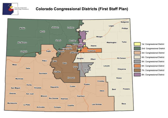


Colorado Congressional redistricting map proposal (Sept. 3)


The biggest news is that the FSP Map basically draws Rep. Joe Neguse (D-Boulderish) and Rep. Lauren “Q*Bert” Boebert (R-ifle) into the same Congressional district (known here as CO-02). Much of Neguse’s former district gets split up into CO-04 and CO-08, while Boebert’s current district (CO-03) moves a little south from her residence in Rifle, Colorado. Neguse’s campaign took quick note of the new potential matchup:

Lauren Boebert, meanwhile, was less enthusiastic about the proposed changes. At roughly the same time on Friday that the Redistricting Commission staff were presenting the new proposed map to the Redistricting Commissioners, Boebert was Tweeting out a completely false accusation against the Commission Staff:
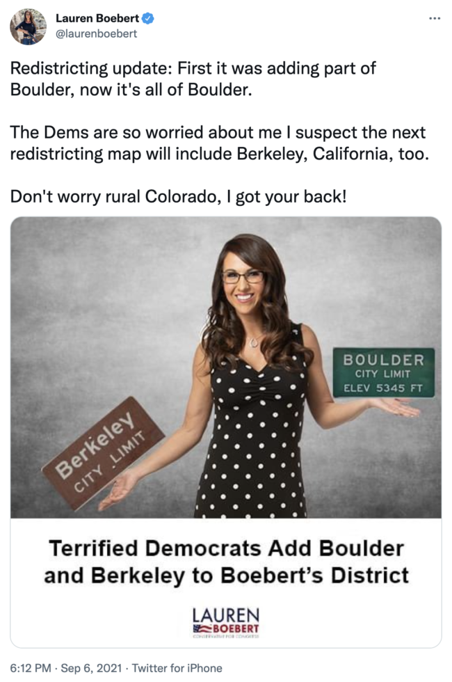
Despite what Boebert says, Democrats did not draw this new map. Furthermore, the nonpartisan staff that are responsible for creating the new map is under specific instructions to NOT consider incumbent residency in their proposals.

This is a good time to remind you that Members of Congress DO NOT need to actually live within the boundaries of the district they represent. The chances are probably pretty good that Boebert would just run in CO-03 instead of challenging Neguse in a district with a slight Democratic lean in terms of registered voters. Congressman Ken Buck (R-Greeley) would have a similar dilemma, since he resides in what would now be called CO-08 — outside of the boundaries of the more familiar CO-04.

State Republican Party Chairperson Kristi Burton Brown (a former staffer on Boebert’s 2020 Congressional campaign) also went after the nonpartisan redistricting staff. From The Colorado Sun:

Brown on Sunday emailed members of the party to urge them to comment on the new map.

“Unfortunately, the commissioners chose to put the interests of the urban Front Range first by diluting the voice of rural Colorado and completely changed the map from the first preliminary Congressional maps,” she wrote. [Pols emphasis]

Of course, the majority of Coloradans just so happen to live along the Front Range. It’s not a conspiracy; it’s just math.

As FiveThirtyEight notes in an examination of the new map proposal, three of the districts would have a Republican lean; three would tilt toward Democrats; and two districts would be toss-up battles:

While the map has two highly competitive seats and assuages the concerns of Hispanic interest groups by making the 8th District 34 percent Hispanic by voting-age population, it has also drawn some criticism for unifying southern Colorado and northern Colorado into one district each (the old congressional map was more oriented in an east-west direction)…

…The map is also unlikely to satisfy Democrats who feel that they deserve more than three safe seats in a state that is trending in their direction.

It’s anyone’s guess as to how the FSP Map might be changed before final approval, but the numbers don’t allow for unlimited options. Combining southern Colorado and northern Colorado, for example, might be tough to avoid simply because there aren’t any big population centers in either area. It’s also tough to create too many competitive seats in a state where Democrats have trounced Republicans in the last two elections, with statewide top-ticket candidates winning by an average margin of 10 points.

Additional proposed maps from the redistricting staff could be presented on Sept. 15 and (if necessary) Sept. 23, but any final decisions are going to be unpopular with somebody. As Redistricting Commissioner Bill Leone, a Republican from Westminster, told The Colorado Sun, “We’re learning every map has some strengths and some weaknesses, there are trade offs with every map.”

Comments

41 thoughts on “So, About that New Congressional Redistricting Map…

  1. "the map introduced on Friday is not necessarily the map that will determine Congressional boundaries for 2022"

    True enough but I can imagine a lot worse maps they can come up with. 

    1. I looked at county populations, which fall into 5 very large, 4 large, 2 medium, and a bunch of small ones. 

      It seems to me that the staff computer pretty much went down the list from largest to smallest. First districts were built from the very large ones. Next they combined large & medium counties. To fill out the population they simply added in adjacent small counties, and then modified the boundaries to get equal populations.

      It seems to me more logical to combine Larimer and Weld, but I guess the weird Larimer and Douglas county combination came because Boulder and Weld were already allocated, and FoCo and Castle Rock were left.

      I’m pretty sure the map will be scratched, so worrying about it any more is wasted energy. However…

      The staff claims the new CO-04 is 15% more Republican based on voting history, and registration of R 35, D 21 and U 42.

      Since they were the only two large population centers, I looked at voting results for Larimer and Douglas County. They approximately flip D-R results, with Larimer having 30,000 more D votes, and Douglas County 20,000 more R votes, with the small, rural counties slowly adding R’s to the balance. Rural areas are declining in population and Larimer and Douglas are growing very quickly. Also, Fort Collins and Castle Rock are suburban counties with higher college educated.

      That leads me to think that a Trumpist Republican would not get the 15% advantage shown by the staff analysis.

          1. A 2019 survey conducted by poll company Civic Science has found that 56% of Americans would like Arabic numerals banned in schools. John Dick, the CEO of Civic Science posted a screenshot of the survey question.

            In the survey, 3,624 people were asked: "Should schools in America teach Arabic Numerals as part of their curriculum?" to which 2,020 people (56%) said "no", and just 29% actually said "yes".

            1. I wish there were a follow up question asking for preferences of what to teach:

              • Greek numbers
              • Roman numbers
              • Arabic numbers
              • Indian numbers
              • Chinese numbers
              • Other:  please specify _____________
  2. Sat thru the first night of public hearings on the map. Pretty clear it will not stand. I was inspired though to draw my own map that incorporates most of the often repeated themes of the public commenters (I also testified about the lack of competitiveness of the map) as well as makes 4 competitive districts. I submitted it around midnight.

    Both NW Colorado and Bolder/Fort Collins were adamantly against the proposed district that put them together. pretty sure that one is dead on arrival.

    My biggest issues:

    1. Only one competitive district, the new one, which they are determined to put in the northern Burbs to make as Latinx as possible.

    2. The map as drawn effectively throws 4 incumbents out of office. It puts Neguse, Buck, and Boebert in one safe Dem district. Buck and Boebert could theorectically run for their old districts as both live close to the borders of them. (Congress members are not required to live in their districts, but they tend to do poorly at the polls if they don't). The map also makes CD6 heavily GOP and CD7 leaning hard enough GOP it is outside the competitive range. Jason Crow would be a goner, but Perlmutter might be able to pull it off, especially if the GOP runs the same caliber of candidates against him they have in the past.

    1. Um.  I don't know what map you're looking at, but the one I see keeps CD-1 Safe D, CD-2 likely D, CD-3 tilt R, (though Boebert could allow Ds to pick it up), CD-4 safe R, CD-5 safe R, CD-6, likely to safe D, CD-7, lean to likely D, (though with Perlmutter, Dems would likely lock it down), CD8, toss-up with a slight D tilt.   The Colorado Sun had a similar take on the map.

  3. The staff consciously drew an alternative to the first map that was based on unofficial population counts. It clarifies things to talk about — especially the idea of a "southern district."  The commissioners have gotten ideas about "communities" — over 2,000 comments, plus testimony at all of their first round of meetings, and now, 4 hearings this week.  I'd join you in assuming this draft is not going to be "final."

    The schedule is for something to be submitted by the end of the month.  I'm pretty certain no one not a part of the Commission knows what map might reach 8 or more affirming votes.  And whatever they submit will be examined by the judges and, I'm betting, someone is going to brief out some arguments to be made.  And the judges can return the map with comments so the commission can try again.

  4. District 2 in this map really doesn't make much sense … plopping highly urban-suburban Boulder in with everything rural to the west. That is too divergent from communities of interest.

    What makes more sense to me is a map pretty much like we have now with a new District 8 that includes Ft. Collins and the I-25 corridor south to Denver city limits.

  5. If Q-bert lives in the side of Garfield County in the proposed new CD 2, it's an easy problem to fix.

    Jayson can just hitch their trailer up to his big ass truck and move it to the CD 3 side of the county.

  6. The commission drew the map with no partisanship? That’s a fat lie.

    Look no further than the fact that Eagle county is nonsensically drawn into CD3, while summit and Garfield, both counties that border Eagle, are put into CD2. First off – it makes zero sense to divide the I-70 communities of Garfield, Eagle and Summit. But of course, Eagle was cherry-picked out so that Kerry Donovan and her fundraising could make a play for CD3 – while Boulder and Fort Collins are pitted against Boebert.

    I’m aghast at the amount of wrenches thrown at this map, all just for the one goal of beating Lauren Boebert. This was a completely partisan play, done at the cost of eviscerating rationale continuous communities. Not to mention that you reduce the fighting chance of Colorado sending a rural representative to congress. This map literally could send zero rural representation to congress. 

    I have no doubt that whoever emerges in cd2 will be a great rep, but to expect a representative to travel regularly from Fort Collins to meeker and Craig is asinine. You’re setting up a scenario where multiple rural counties won’t see their rep, while the present map gives a much better chance of reps being able to interface with their communities.

    There was one goal with this map, and it was a goal that trumped contiguous communities and rural representation. Put this map in the trash heap, please. 

    Hope you’re all well – Miguel Ali 

    1. For those of us with partisan leanings (and those of us who are probably political hacks) it is difficult, perhaps close to impossible, to back off and truly look at the state from the communities of interest point of view. There is no way the west slope/east slope district proposals are not partisan. From the beginning that has been what conservative groups like Club 20 pushed, claiming it was to preserve rural interests but instead it was to preserve Republican interests. 

      Those of us who have played with mapping tools have found many other ways to draw the lines. Some of us in rural Colorado have literally not had time to look at the party numbers as we draw lines, but instead see a genuine community of interest that drives a southern district map. A southern district plus the Jeffco/central mountain district in the first staff plan come as close as anything to reflecting true communities of interest (local economies, transportation corridors, rivers, etc – notice I did not say party domination). There are problems with the first staff plan but it's around the edges (the Summit split probably does not need to happen, for example). 

      1. Don't know if you read the staff's memo or not … but I was astounded to read they'd been able to draw districts that had "Equal Population. The population of each of the districts is within one person of the ideal district size of 721,714." 

    2. Muhammad Ali Hasan

      Nice that you are impugning the staff of the commission.  How many do you know personally?  And how can you read their motivations so well to enable you to determine they are lying????

      I don’t know any of the staff … but figure that it may be worthwhile to consider what they say as a possible explanation — so here’s what I think is a reasonable explanation of why the First Congressional Staff Plan emerged as it did.

      However, if adding the tribal lands to an Eastern Plains district is the direction that the Congressional Commission decides to follow, this can be done as a simple amendment to the Preliminary Congressional Plan. Nonpartisan staff believes that it is instead more beneficial to the future work of the Congressional Commission for the First Congressional Staff Plan to place the subject area in a largely southern district. Further, the Congressional Commission now has two distinct plans created by nonpartisan staff that can be amended by the commission.

      By submitting this First Congressional Staff Plan, nonpartisan staff is not recommending or suggesting that the Congressional Commission approve a congressional redistricting plan with a largely southern district. Again, that is a choice for the Congressional Commission to make. No congressional redistricting plan will be perfect. There are advantages and disadvantages to both types of plans.

          1. That's a weird map, too. And also a bad map. I am withholding judgement on the proposed map as I think about it. I do wonder about a more "North Front Range" –  "Denver Metro" – "South Front Range" – parcel out everything else – map.

            1. Look at the population centers, and where they are in the state. Pueblo is insufficient to anchor a rural district, whether West, South or East. Pueblo plus Mesa anchors the West; Pueblo plus what? anchors the South or East.

              The North has three counties that could anchor two districts: Boulder, Larimer and Weld. Add in Adams, and the North districts can be created.

              Weld County and various Republicans make a big deal out of rural vs urban, calling Adams an "urban" district. That is ridiculous, as Greeley is as much or more urban than Adams. In any case, they are all in the same, I-25 wall-to-wall, suburban corridor.

              You can't make a rural district, implying farmers and ranchers, without adding in resorts and tourism in the West, and Suburbs on the East.

    3. The representatives for CD3 and CD4 have routinely travelled hundreds of miles through their giant rural districts- which has made them challenging to campaign in, and advantaged incumbents. 
      So Miguel Ali’s  assertion that “  to expect a representative to travel regularly from Fort Collins to meeker and Craig is asinine“ is unfounded. 
       

      If this map holds, Boebert will have to learn how to appeal to moderates…which is kind of the point of this whole exercise.  Except for the safe R ( Doug Co) and safe D (Denver) districts,  representatives will need to represent a different range of constituents. 


      1. "If this map holds, Boebert will have to learn how to appeal to moderates"

        Muy chistoso. Truly you jest.

        It will be easier for her to move to the other side of Garfield County into CD 3.

      2. FoCo -> Meeker (mythical congressional district): 276 mi / 4:46 travel time

        Greeley -> Springfield (actual congressional district): 295 mi /4:38 travel time

        Julesburg -> Trinidad (actual congressional district) 333 mi / 5:04

        Meeker -> Pueblo (actual congressional district): 334 mi / 5:14 travel time

      3. Having already spent more time in Craig than I care to recall, I wouldn’t recommend traveling from there to anywhere, or vice versa, not to even my worst enemies . . .

        . . . So, I guess I’m OK with Qpé doing it, she apparently needs the mileage to buy cheese, or something?

        (I don’t think MAH will have to worry himself about her having to make that drive after 2022, however . . .)

        1. I fell into a bunny hole on FB last night that was quite entertaining.  The post has over 150 shares and 1.5mm comments.  An extraordinary level of commenting coming from MAH based on his belief the vaccines have not been proven safe.  

          1. I followed some of his comments on the subject and argued with him some, but Lordy! He has become completely misguided and unreasonable…but he gets a lot of attention.  😉

    4. "expect a representative to travel regularly from Ft. Collins to Meeker and Craig is asinine………"

      How so? Representatives already travel from Pueblo to Craig. Or from Julesburg to Trinidad.

      I have friends in Craig. Maybe they might like a real representative; whether Republican or Democrat; if he/she is not a Trump lapdog.

    5. "to expect a representative to travel regularly from Fort Collins to meeker and Craig is asinine."

      How do you think the system currently works? You do know that it's hard to get to 700,000 rural people in a district in this state without drawing a map that includes <gasp> a more populated area!

      1. I'm not a big fan of his but…..

        Representative Don Young is about 50 years older than Q-bert and must travel the entire state of Alaska. And Juneau to Nome is a little further than the trip from Craig to Fort Collins.

        1. Minnesota 7th's northern border is Canada and its southern border is about 25 miles north of Rock Rapids, IA.  Long represented by Colin Peterson, he often traveled the district in his single-engine Beechcraft.  Over 400 miles end-to-end.  But Rep Young wins the prize! 

  7. The Commission also has maps submitted by Commission members they are considering, and a whole bunch from the public (myself included) they are sifting thru. There is a Map Analytics Committee that is currently assessing public-submitted maps and they are checking for which ones meet the constitutional requirements, etc. and then will be moving the ones with enough merit on to the full Commission.

    Bottom line: this is long from over, but will all happen very quickly due to time limits when it has to be done.

  8. I shouldn’t have said the commission willfully lied – I’ll walk that back because that was an exaggeration – nonetheless, it was rude of me and I’m sorry to those it upset. My concern that this was a partisan play: of course the commission is not partisan and I appreciate that – but to me, someone gave this commission horrible advice. It is absolutely suspicious to carve Eagle County out of the I70 corridor, and place a choice candidate into a preferred district. There were many asinine decisions made on this map, and my suspicion is that it was all to stack the deck against the candidacy of one person. Again: Yes, the commission is not partisan and I take such words back. But this map was terribly suspicious.

    As far as the assertations above that Fort Collins to Craig is an amenable drive – have any of you ever done that drive? CD2, in the form on this map (along with some of the other districts) is a mess. Those northwestern Western Slope counties are basically abandoned because they’re rarely going to see their rep. It’s a critical topic to me, as someone who partially grew up in the Western Slope. 

    And yes (might as well go here too – lol) – I’m not for vaccine mandates. Both my son and my wife have been injured by vaccines, that altered their lives forever. The current Covid vaccine isn’t even the traditional form, where dead viral particles (of the targeted virus) are injected into the body – rather – it is coded-rna, meant to deliver instructions to your ribosomes and have it create a particular set of proteins. It is incredible technology. Unfortunately – We have no clue the affect that such RNA will leave on those ribosomes long term (and how it affects all proteins produced after the fact), second we also don’t know how much protein is made off of each RNA, third we have no clue how quickly the RNA decays (and is no longer used) and most concerning – we have no confirmation that the RNA fully decays and is disposed. As the University of Wisconsin proved in the 1970’s, RNA can transcribe into DNA, and now have a greater affect on the body. 

    The protein you want fighting Covid is the N-Protein (nucleocapsid). To my knowledge, the vaccine doesn’t produce those. The strongest defense against Covid is the T-Cell fight – fortunately, the Spike Protein (with the mRNA manufacture) does induce T-Cell response. However, if you induce T-Cell response without the real Covid virus present, you theoretically could be risking a cytokine storm (which if correct, would explain the heart attacks, blood clots, amputations, deaths, etc). Even if that theory is not true (and it may not be) – we have no clue who is most at risk with this shot, because….. we have zero long term study on it. 

    Dr Luc Montagnier, Mike Yeadon and Robert Malone have all voiced concern that this vaccine may cause antibody dependence enhancement (ADE) – the theory that, rather than the spike proteins neutralizing Covid, such proteins will actually ‘carriage’ mutated Covid viruses into the cells. When you consider that Covid deaths in Israel right now are almost 2X what they were, in comparison to this time last year, and the fact that Israel is doing multiple doses of these shots….. well…. the data speaks for itself. 

    If you want the shot – by all means – get it. I’m actually glad it is legal and accessible, because I’m happy to say: I may be wrong about my concerns (and I hope I am, on the basis of the number of people who have received it). I’m also grateful to the scientists who produced it because I know they are doing the best for humanity that they can. But to assume these shots are perfectly safe for all? That is fantasy. 

    Last note: I’m not a doctor. My research is on the basis of being a layperson and is purely opinion. Hope you’re all well!

Leave a Comment

Recent Comments


Posts about

Donald Trump
SEE MORE

Posts about

Rep. Lauren Boebert
SEE MORE

Posts about

Rep. Yadira Caraveo
SEE MORE

Posts about

Colorado House
SEE MORE

Posts about

Colorado Senate
SEE MORE

114 readers online now

Newsletter

Subscribe to our monthly newsletter to stay in the loop with regular updates!